Even engineered dikes and levies can fail in many different ways. But the berms at the Smurfit-Stone mill site are not approved flood control structures. In fact, they were built by bulldozing gravel into piles! The berms have not been regularly maintained since the mill closed in 2010, and beavers and rodents continue to burrow into the berms to make their homes. As such, the potential for failure due to piping, breaching, or overtopping is higher than for levees built to current engineering standards. As we saw in 2018, even a moderate spring runoff can compromise the berm, causing contaminants to leak into the river. Climate change will lead to more frequent and intense floods, which multiply the risks of berm failure. River Design Group’s recent study examined and modeled three different potential berm failure scenarios:
Piping – Failure from inside when water seeps under and creates boils or pushes through the berm where weak points exist, such as where rodents have dug Swiss-cheese-like holes.
Erosion Breaching (termed mass wasting) – Failure due to water eroding away at weak points and ultimately punching through the berm.
Overtopping – Failure due to high water flowing over the top of the berm at lower and/or weaker points.
Piping, Breaching, and Overtopping failures were modeled for different flood events:
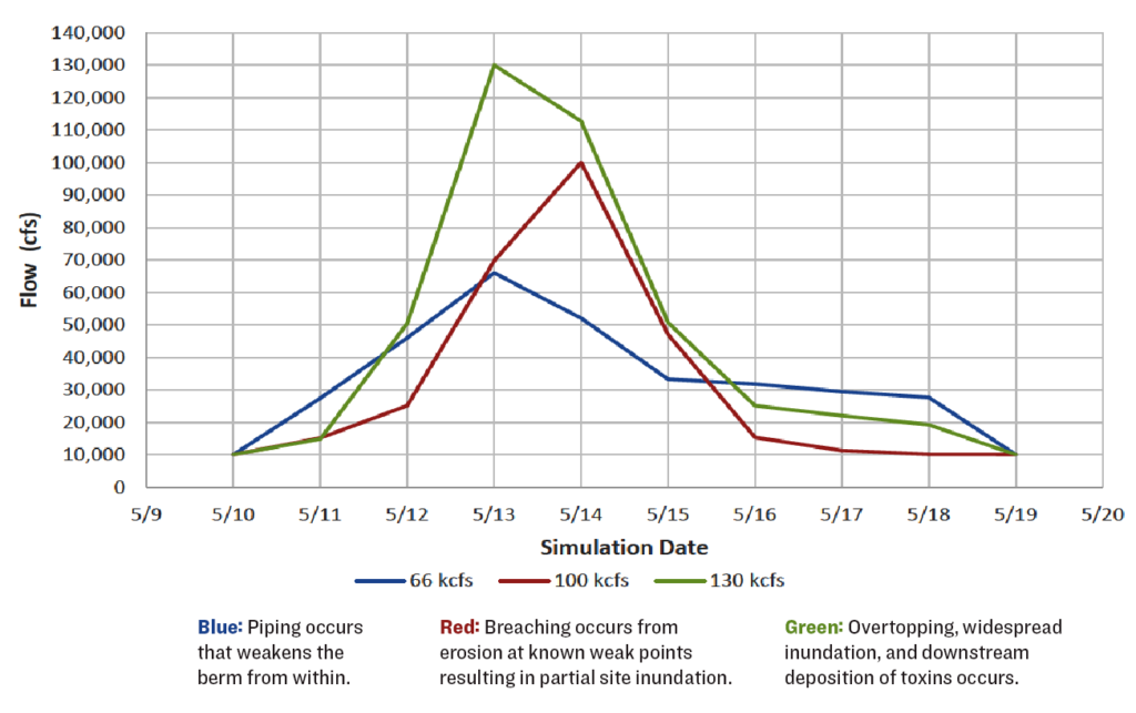
 Watch Piping Failure at 66,000 cfs
Piping failure occurs at flows of 66,000 cubic feet per second (cfs), the historic 100-year flood level, and causes inundation at the upstream and downstream ends of the Smurfit-Stone mill site. These flows are only 10,000-12,000 cfs more than those that occurred in 2018. Video >>
 Watch Erosion Breach Failure at 98,000 cfs
Erosion breaching, modeled under a future climate-driven 100-year flood, occurs at ~100,000 cfs. Inundation of the upstream third of the Smurfit-Stone mill site brings floodwaters to the edges of the sludge ponds and dumps, where the most toxic materials are stored. Flows are only about 25,000 cfs more than the devastating 1908 flood. Video >>
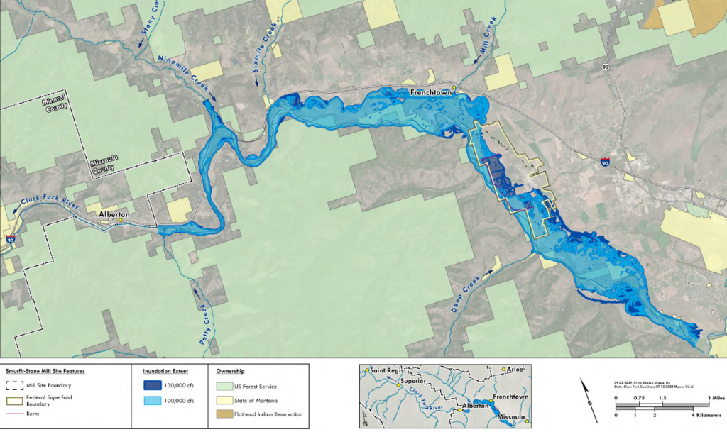
 Watch Overtopping Failure at 130,000 cfs
Overtopping failure, modeled under a future climate-driven 500-year flood, occurs at 130,000 cfs. Inundation of the entire floodplain floods one of the landfills and washes toxins downstream for hundreds of miles. Video >>
Although we have nearly 100 years of flow records for the Clark Fork River, it is difficult to understand the likelihood and frequency of large floods. This challenge is not unique to the Clark Fork River. Across the western United States and across the world, floods have exceeded our predictions and our imagination. History shows that extreme floods happen, and that century-long datasets may not prepare us for the size or severity of future climate-driven flooding. Despite the difficulty, it is necessary to predict the magnitude of future floods in order to safeguard critical infrastructure, human life, and environmental quality. First, let’s look at what history shows us.
The 1908 Clark Fork River Flood
During the 1908 flood, historical photographs show inundation of portions of Butte and Missoula, and newspaper records describe widespread destruction and threats to the then-new Milltown dam. The breadth of flood-deposited mine sediment provides another clear indication of the size of the flood. While the 1908 flood is the largest we know of on the Clark Fork River, we have no written record and limited natural evidence to help us understand the occurrence of even larger floods before it.
Peak flow during the 1908 flood was estimated at 48,000 cfs above Missoula, which is nearly 50% bigger than the largest recorded flow of 32,500 cfs in 2018. Although the gauge below Missoula does not record data back that far in time, based on the observed relationship between peak flows above and below Missoula (and implicitly, the contribution of the Bitterroot River), peak flows during the 1908 flood below Missoula are estimated at around 70,000 – 75,000 cfs. The 1908 disaster was un-imaginable at the time, but we must imagine extreme floods in the future in order to understand the risk of a catastrophic flood at the Smurfit-Stone site.
The 2022 Yellowstone River Flood
The 2022 flood of the Yellowstone River is an example of a recent extreme event in a nearby river system, and it provides a contemporary perspective on our ability to anticipate the likelihood of extreme floods. Peak flow during this flood was measured at 54,700 cfs, almost twice as large as the previously observed largest flow of 32,200 cfs in 1997. Based on the historical data, the Yellowstone River has a 1 in 100 annual chance of a 33,000 cfs flood (similar to 1997), a 1 in 500 chance of a 38,000 cfs flood, and a 1 in 1000 chance of a 40,000 cfs flood. To put these risks in perspective, 1 in 100 children are allergic to shellfish; gamblers have a 1 in 500 chance of drawing a flush in poker. The 2022 flood was substantially less likely than any of these, perhaps closer to a 1 in 100,000 chance–the same chance you currently have of being hospitalized for COVID-19. The estimated likelihood of the 2022 flood was infinitesimal, yet it happened in our recent memory.
Future Flood Risks
Although the precise future climate conditions for western Montana are difficult to predict, a warming atmosphere has long been predicted to drive intensification of the water cycle and an increase in the frequency of extreme precipitation. In the tempestuous future climate predicted by climate scientists, we can expect a shift in the causes, timing, and frequency of higher flows, with fewer occurrences due to snowmelt and more due to rain. High flows triggered by heavy rain can raise river levels more quickly and unpredictably than those occurring in spring months driven by snowmelt. Overall warmer weather will result in more rainfall in winter, less water stored as snow, and earlier melt of the thinner snowpack with increased chances of the types of rain-on-snow events that caused the 2022 Yellowstone River flood. For some rivers, peak flows may no longer occur in spring, but may occur in fall and winter instead.
Our understanding of how a warming climate intensifies the water cycle challenges the use of historical flow records to anticipate future floods. As modern climate models gain greater precision and resolution, we are forming flood risk assessments that incorporate historical information along with the effects of current and future climate conditions. Climate-informed assessments suggest that future floods may be much larger and more frequent than those predicted solely using historical records.
The extreme toxicity and persistence of the contamination at the Smurfit-Stone site underscores the need to consider flood risk over a long period of time. On top of the increase in flood sizes due to climate change, the overall chance of a large flood increases over longer periods of time. For example, there is a 40% chance of a 1-in-100 flood and nearly a 10% chance of a 1-in-500 flood occurring at least once in any 50-year period. The risk of a catastrophic flood becomes quite substantial over time frames relevant to the Smurfit-Stone site. This means that flows modeled in this report causing berm failure—piping at 66,000, breaching at 98,000, and over topping at 130,000 cfs—aren’t remote pie-in-the-sky numbers. They could happen anytime, meaning that cleanup plans at the Smurfit-Stone site must be informed by climate-driven risk assessments to ensure the safety of the Clark Fork River and downstream residents.
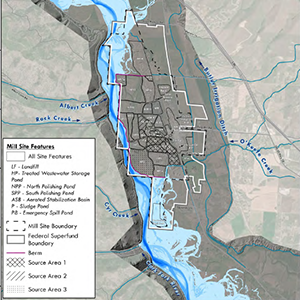
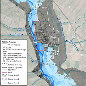
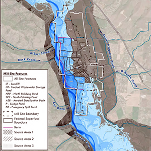
During a flood, toxic soil and other contaminated materials would wash downstream due to failure of the berms. Fine-grained materials, such as fly ash, easily mix with water flowing through and leaving the Smurfit-Stone site. Toxins would likely be dispersed across the floodplain downstream and deposited in low-velocity areas, such as Frenchtown Slough. Contaminants that enter the main flow of the river would likely be transported further downstream, through Alberton Gorge and possibly as far as Thompson Falls Reservoir or Lake Pend Oreille.
The Clark Fork Coalition and American Rivers retained River Design Group to develop a reach-scale hydraulic model for use in evaluating the risk of failure for the berms separating the Clark Fork River from contaminated floodplain areas at the Site. The study improves the understanding of river flows and hydraulics associated with historical and potential future conditions resulting from climate change scenarios.
- Summary
- Perspectives on flood risk
- Full report (prefaced by EPA letter)
- Public presentation by River Design Group, Alberton Community Center, June 18, 2024
- Videos